Ecuador Itinerary: 7, 10 or 14 Days, Andes to Galápagos
An Ecuador itinerary for 7, 10 or 14 days, on the mainland or with Galapagos: drive times from Quito, volcano heights and where the Amazon fits.

An Ecuador itinerary needs seven days for the volcano road south of Quito, as far as Baños and Chimborazo. Ten days add the Amazon, and fourteen add Cuenca as well, or swap both for the Galápagos. Every version starts and ends in Quito: the international flights land there, the road through the volcanoes starts there, and the planes to the islands leave from there in the morning.
Every drive time below comes from Google Maps on 17 November 2026, every flight from Google Flights for February 2027, and every volcano height from Ecuador’s Instituto Geofísico (IG-EPN), which monitors them. We are based in Quito, and these are the routes we would plan for a first visit.
How long an Ecuador trip itinerary needs
| Days | Mainland only | With the Galápagos |
|---|---|---|
| 7 | Quito, Cotopaxi, Quilotoa, Baños, Chimborazo | Two nights in Quito, four on Santa Cruz |
| 10 | Add Otavalo and two nights in the Amazon | Quito, Cotopaxi, Quilotoa, then six island nights |
| 14 | Add Cuenca as well | The volcano road, then Santa Cruz, Isabela and San Cristóbal |
Seven days is the least we would plan for the mainland. The loop south of Quito takes five of them, and the first and last go to flights. From the airport at Tababela to the old town is 44 km, which Google Maps put at 58 minutes in traffic.
From the United States the flights are short. For Tuesday 9 February 2027, Google Flights listed three nonstops from Miami to Quito, with LATAM and American, taking 4 h 17 to 4 h 24. From New York to Quito there was one nonstop, Avianca’s overnight flight of 6 h 30; the rest changed planes and took from 8 h 37. Most of those flights land in the evening, so day 1 is a night in Quito.
The order: sleep in Quito, go higher by day
Quito stands at 2,850 m, according to UNESCO, so the first night of any trip is already at altitude. Give the city two nights before going higher. After that, the big mountains are day visits. You walk around a lagoon at the foot of Cotopaxi, look down into the crater of Quilotoa and walk up from the refuge on Chimborazo, and each night you sleep lower down.
These are the heights the Instituto Geofísico gives for the volcanoes on the routes below, in the order you meet them:
| Volcano | Height | Where you see it |
|---|---|---|
| Guagua Pichincha | 4,776 m | Above Quito |
| Imbabura | 4,621 m | Above Otavalo |
| Cotopaxi | 5,897 m | From the Limpiopungo lagoon |
| Quilotoa | 3,914 m | From the crater rim, above its lake |
| Tungurahua | 5,020 m | Above Baños |
| Chimborazo | 6,263 m | From the Carrel refuge |
The institute lists three of them as active. Guagua Pichincha last erupted from 1999 to 2001, Tungurahua from 1999 to 2016, and Cotopaxi from October 2022 to July 2023. Imbabura, Quilotoa and Chimborazo are listed as potentially active.
Baños breaks the pattern in the other direction. The town sits far below Quito, in the valley of the Pastaza river, at the head of the road that drops to the Amazon, and it is the lowest night of the seven-day loop. Our guide to South America altitude explains how the altitude risk is measured and what helps.
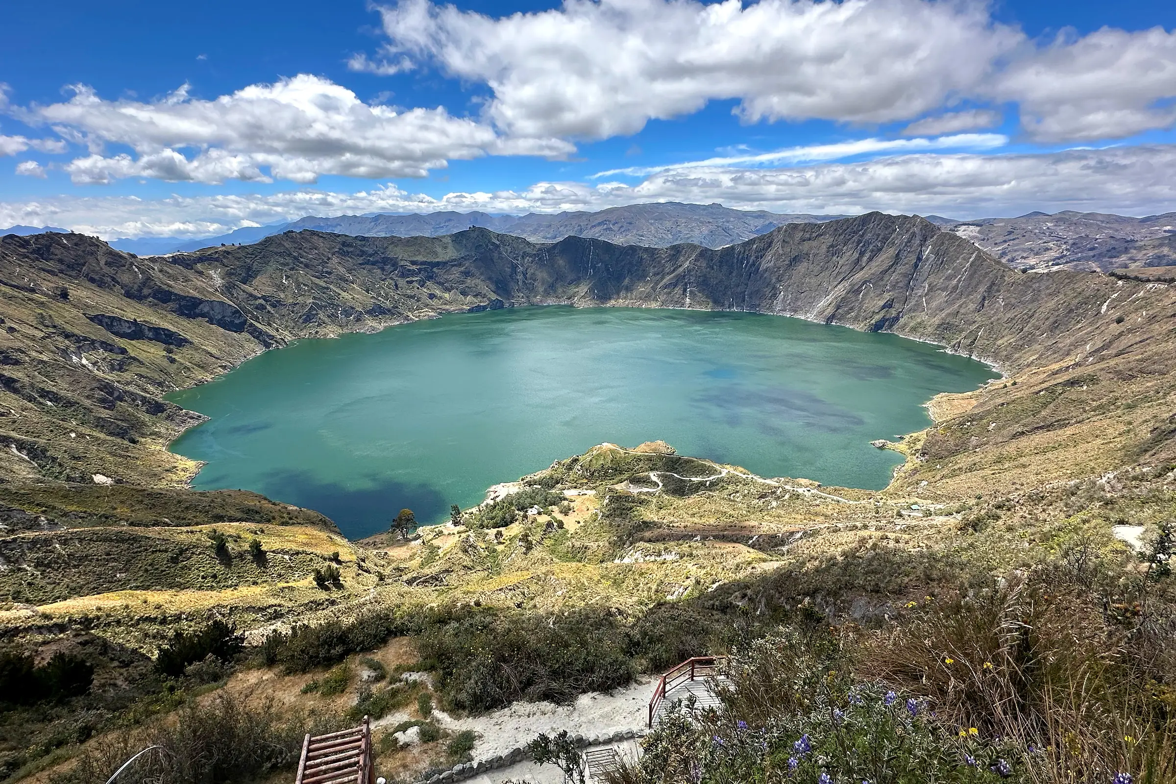
The crater lake of Quilotoa from the rim. The IG-EPN lists it as a caldera holding a crater lake.
Drive times between the stops
Google Maps gave these on 17 November 2026, with the traffic of the moment and no stops. Riobamba here means Hostería La Andaluza, north of the city, where our longer trips sleep. Add time for lunch, photographs and the slower trucks on the Panamericana.
| Leg | Km | Drive |
|---|---|---|
| Quito to Otavalo | 102 | 2 h 07 |
| Quito to Mindo | 102 | 2 h 12 |
| Quito to the Limpiopungo lagoon, Cotopaxi | 86 | 1 h 33 |
| Hacienda La Ciénega, near Lasso, to Quilotoa | 95 | 1 h 50 |
| Quilotoa to Baños | 154 | 3 h 07 |
| Baños to Puyo | 60 | 1 h 22 |
| Baños to the upper Napo, at Ahuano | 177 | 3 h 48 |
| Baños to Riobamba | 59 | 1 h 23 |
| Riobamba to the Carrel refuge, Chimborazo | 53 | 1 h 23 |
| Carrel refuge to Quito | 220 | 3 h 59 |
| Ahuano to Riobamba | 235 | 5 h 07 |
| Riobamba to Cuenca | 271 | 5 h 09 |
Two of those legs shape every plan. Quilotoa to Baños is three hours whatever you do. The drive from Chimborazo back to Quito is four, and we put it on the afternoon after the refuge, because the alternative is a sixth night on the mainland.
Seven days on the mainland
- Land in Quito and rest. The first night at 2,850 m is the one to take easy.
- The old town, a UNESCO World Heritage Site since 1978: the Plaza de la Independencia, the Basílica del Voto Nacional and the view from the Panecillo. In the afternoon, north to the Mitad del Mundo monument on the equator.
- South to Cotopaxi National Park, an hour and a half by road, and a walk around the Limpiopungo lagoon at the foot of the volcano. The night is at a hacienda near Lasso.
- West to Quilotoa, 1 h 50 from the hacienda, and the view from the crater rim. Then three hours east to Baños.
- The Pailón del Diablo waterfall in the morning, on the road east of Baños, and 1 h 23 to Riobamba in the afternoon.
- Up to the Carrel refuge on Chimborazo and a slow walk higher, then 3 h 59 north to Quito.
- Fly home.
Days 2 to 6 follow the mainland half of our longer trips, and the order is the point of it: two nights at Quito’s height before Cotopaxi, and the longest drive placed where it costs no extra night. Quilotoa is also on the Quilotoa Loop, a hike of several days between villages; this route drives to the rim.
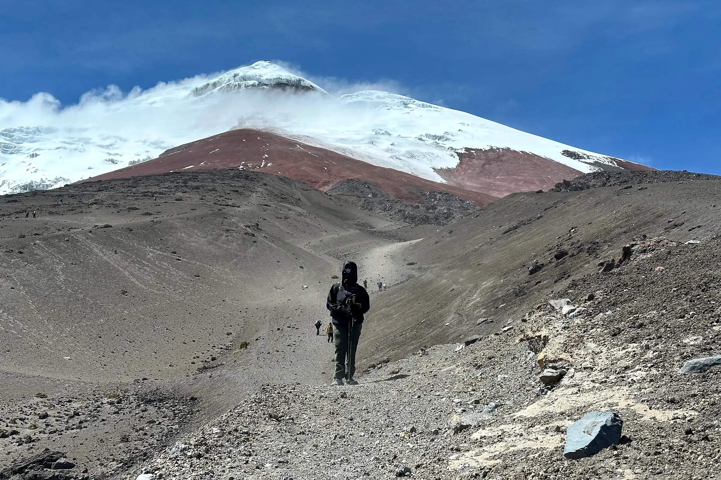
Cotopaxi from the trail to the refuge, the first big volcano on an Ecuador itinerary south of Quito.
Ten days: Otavalo and the Amazon
Ten days keep the same volcano road and add two things: a day north of Quito, and two nights in the rainforest on the way between Baños and Chimborazo.
| Day | Where you sleep | What fills it |
|---|---|---|
| 1 | Quito | Arrival |
| 2 | Quito | The old town and the equator |
| 3 | Quito | Otavalo and its market, 2 h 07 each way, below Imbabura |
| 4 | Hacienda near Lasso | Cotopaxi and the Limpiopungo lagoon |
| 5 | Baños | Quilotoa on the way |
| 6 | Upper Napo, at Ahuano | The Pailón del Diablo, then 3 h 48 down into the Amazon |
| 7 | Upper Napo | Forest walks and a canoe on the river |
| 8 | Riobamba | The long road back up, 5 h 07 |
| 9 | Quito | Chimborazo, then north to Quito |
| 10 | Fly home |
Day 8 is the price of the Amazon by road: five hours from the river back to the Andes. If that is too much, swap the forest for Cuenca. After Chimborazo, drive south to Cuenca instead of north to Quito, give it two days and fly home from its airport.
Fourteen days on the mainland
Fourteen days add Cuenca to the ten-day route, and a slower pace in Baños. Cuenca’s historic centre has been a UNESCO World Heritage Site since 1999, set in a valley crossed by four rivers in the south of the country.
| Days | Where you sleep | What fills them |
|---|---|---|
| 1 to 3 | Quito | Arrival, the old town and the equator, a day in Otavalo |
| 4 | Hacienda near Lasso | Cotopaxi |
| 5 and 6 | Baños | Quilotoa on the way in, a full day in Baños |
| 7 and 8 | Upper Napo, at Ahuano | The road down, then the forest |
| 9 and 10 | Riobamba | The road back up, then Chimborazo |
| 11 to 13 | Cuenca | 5 h 09 by road from Riobamba, then two days in the city |
| 14 | Fly from Cuenca |
From Cuenca you fly rather than drive back. On 10 February 2027 there were six nonstop flights from Quito to Cuenca, with LATAM and Avianca, taking 54 minutes to 1 h 10, and the same airlines connect Cuenca with your international flight through Quito or Guayaquil.
If you would rather see cloud forest than Otavalo, swap day 3 for a night in Mindo, 2 h 12 west of Quito. The road from Mindo to the hacienda below Cotopaxi runs back through Quito and took 3 h 29.
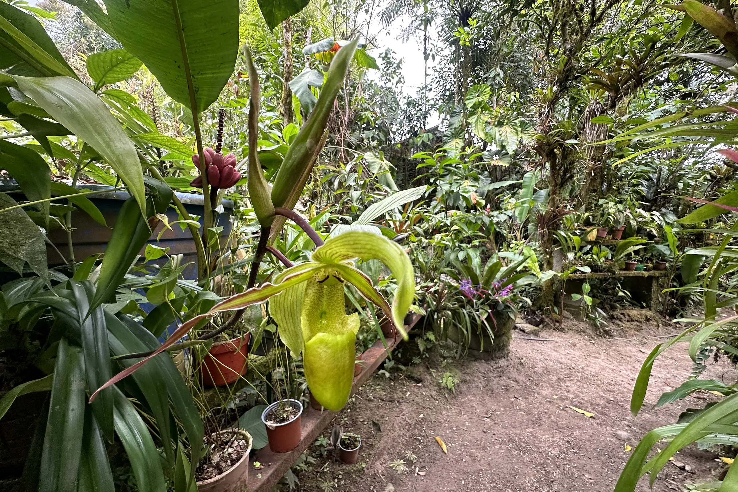
An orchid garden in the cloud forest at Mindo, two hours west of Quito.
Ecuador travel itinerary with the Galápagos
The islands change the shape of the trip, for one reason: the planes to Baltra leave the mainland only in the morning. On 10 February 2027, the flights from Quito to Baltra that reached the islands the same day left between 07:27 and 11:05. Only the 11:05 Avianca flight was nonstop, at 2 h 15; the rest stopped in Guayaquil. So the night before the islands is always on the mainland, and the volcano road has to finish back in Quito. The islands keep their clocks an hour behind: that 11:05 departure landed at 12:20.
Seven days. Two nights in Quito, with the old town and, if you like, a day trip to Cotopaxi, then four nights on Santa Cruz: fly in on day 3, two boat days to the islands nearby, and the flight back on day 7.
Ten days. Quito, Cotopaxi and Quilotoa, then six island nights on Santa Cruz and Isabela. This is how our Ecuador and Galapagos tours run in their ten-day version, with a private guide and driver on the mainland. The twelve-day version adds Baños and Chimborazo, and the fifteen adds two nights in the Amazon at Ahuano. In all three the island nights stay as they are; the mainland is where days come and go.
Fourteen days. The full volcano road, then three islands, flying into Baltra and out of San Cristóbal so you never cross the same water twice.
| Days | Where you sleep | What fills them |
|---|---|---|
| 1 and 2 | Quito | Arrival, the old town and the equator |
| 3 | Hacienda near Lasso | Cotopaxi |
| 4 | Baños | Quilotoa on the way |
| 5 | Riobamba | The Pailón del Diablo, then 1 h 23 south |
| 6 | Quito | Chimborazo, then 3 h 59 north |
| 7 and 8 | Santa Cruz | Fly to Baltra, the highlands, a boat day |
| 9 and 10 | Isabela | The boat from Puerto Ayora, Las Tintoreras, Sierra Negra |
| 11 and 12 | San Cristóbal | The small plane from Isabela, Kicker Rock |
| 13 | Quito | Fly back from San Cristóbal |
| 14 | Fly home |
On day 13, flights from San Cristóbal to Quito left at 10:30 and 13:05 on our sample date, both through Guayaquil, and landed at 14:46 and 17:35. If your international flight leaves Quito late that night, the extra hotel night can go. Our Galápagos itinerary has the boats, the small planes and the island days in detail.
Cuenca and the islands also fit together. LATAM’s 08:10 from Cuenca reached Baltra at 11:17 on our sample date, with a change in Guayaquil.
Where the Amazon fits
There are two ways in, and they lead to different forest.
By road, the Amazon starts below Baños. Puyo is 1 h 22 away, and La Casa del Suizo, a lodge on the upper Napo at Ahuano, is 3 h 48. That is the version in the routes above and in the fifteen-day version of our trip, because it hangs off the volcano road without a flight. From Quito, the road east to Tena took 3 h 47.
By air, LATAM flew Quito to Coca in 40 minutes on our sample date, one flight at 10:00. From Coca the lodges of the lower Napo are reached by boat. One of them, Napo Wildlife Center, stands inside Yasuní National Park, is run by the Kichwa Añangu community, and sells stays from four days and three nights. With that length it fits a fourteen-day trip, not a seven-day one.
It rains in the Amazon all year. Our guide to the best time to visit Ecuador has the figures for the forest, the Andes and the islands month by month. In Quito, INAMHI’s 1981-2010 normals give 21.5 mm of rain in July and 171.2 mm in April, which is why June to September is the easiest time for the volcano road.
The coast, and why these routes leave it out
The UK Foreign Office, in its travel advice updated on 1 November 2026, advises against all but essential travel to seven coastal provinces: Esmeraldas, Manabí, Santa Elena, Guayas, El Oro, Los Ríos and Santo Domingo de los Tsáchilas. The one exception is airside transit at Guayaquil airport.
That is why none of the routes above drives to the coast or through Guayaquil. Changing planes there on the way to the islands stays airside. Driving from Cuenca down to Guayaquil airport, 197 km and 3 h 44 through the mountains of El Cajas, does not, so from Cuenca we would fly.
For trips that put Quito and the volcanoes next to the islands, our Ecuador tours page has every route we sell in the country.
The questions we get on this
- How many days in Ecuador is enough?
- Seven days for the mainland, ten if you add the Amazon, and fourteen to add the Galápagos at a pace that leaves time on each island. The loop south of Quito through Cotopaxi, Quilotoa, Baños and Chimborazo takes five days by road, and the first and last days go to flights. The islands need at least four nights of their own.
- How long does it take to fly from the US to Ecuador?
- About four hours and twenty minutes nonstop from Miami to Quito. For 9 February 2027, Google Flights listed nonstops with LATAM and American taking 4 h 17 to 4 h 24. From New York there was one nonstop to Quito, Avianca’s overnight flight of 6 h 30; the other options changed planes and took from 8 h 37.
- Is 10 days enough for Ecuador and the Galápagos?
- Yes, if you keep the mainland short. Three days in the Andes, for Quito, Cotopaxi and Quilotoa, leave six nights for Santa Cruz and Isabela, which is how the ten-day version of our Ecuador and Galápagos trip runs. The flights to Baltra leave the mainland only in the morning, so the night before the islands is always spent in Quito.
- Is 7 days enough for Ecuador?
- For the Andes, yes: Quito, Cotopaxi, Quilotoa, Baños and Chimborazo fit in seven days, with two long drives of about three and four hours. Seven days is too short to add the Amazon or the Galápagos and see the volcanoes as well; for the islands alone, seven days means two nights in Quito and four on Santa Cruz.