Chile · Travel guide
Atacama Desert Map: 13 Places, Altitudes and Distances

Atacama desert map of northern Chile: San Pedro, the Valle de la Luna, El Tatio, the salt flat and both borders, with altitudes and distances.
This is the reasoning we use when we date a trip, not an article written to fill a blog. The Chile itineraries it feeds are here.

This Atacama desert map shows the part of northern Chile that travellers actually visit: the oasis town of San Pedro de Atacama, at 2,407 m, with the Valle de la Luna 13 km to the west, the El Tatio geysers 67 km to the north at 4,320 m, the Salar de Atacama salt flat to the south, and the borders with Bolivia and Argentina to the east. Below are three maps at three scales, drawn by us from public geographic data, a table with the altitude and straight-line distance of every place on them, and their coordinates at the end.
Where is the Atacama Desert
In northern Chile, between the Pacific Ocean and the Andes, south of Peru and west of Bolivia and Argentina. NASA’s Earth Observatory describes it as one of the world’s driest deserts, where salt pans and gorges meet the foothills of the Andes.
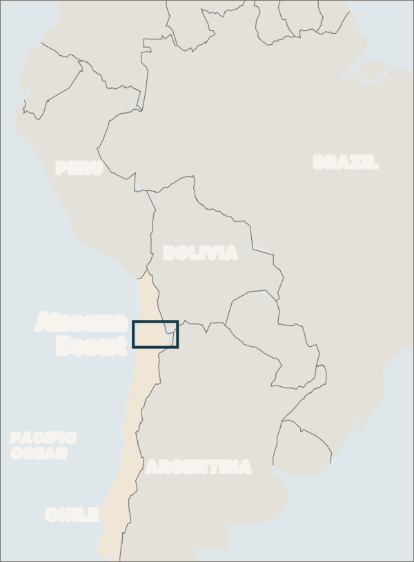
The box marks the area of the detailed map below. Map by Latin Lands from Natural Earth data (public domain).
The visitor’s Atacama is a smaller area inside it: the Antofagasta Region, and within it the commune of San Pedro de Atacama, in the province of El Loa. That is where the oasis, the salt flat and the high lagoons are, and where every tour of the desert starts.
The Atacama Desert map: from the coast to the borders
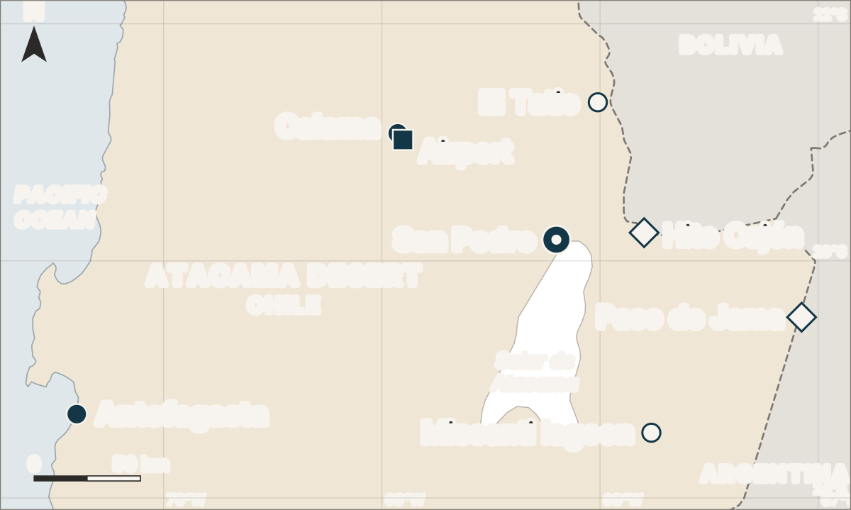
Northern Chile from Antofagasta to the Bolivian and Argentine borders. Dashed lines are international borders; the salt flat outline is generalised. Map by Latin Lands from Natural Earth data (public domain) and Wikidata coordinates.
Read the map from left to right and it explains the whole logistics of a visit. The coast at Antofagasta is 239 km from San Pedro in a straight line. The airport that serves the desert is inland, at Calama, 86 km from San Pedro. And the town sits at the northern tip of the Salar de Atacama, with the high Andes, the geysers and the borders all within a morning’s drive to the north and east.
| Place | Altitude | From San Pedro |
|---|---|---|
| San Pedro de Atacama, the oasis town | 2,407 m | |
| Valle de la Luna, eroded valley | 13 km W | |
| Puritama, hot springs in a gorge | 27 km NE | |
| Licancabur, volcano on the border | 5,920 m | 34 km E |
| Toconao, village by the salt flat | 2,485 m | 37 km SE |
| Hito Cajón, border post to Bolivia | 4,549 m | 41 km E |
| Laguna Chaxa, flamingo lagoon | 2,299 m | 47 km S |
| El Tatio, geyser field | 4,320 m | 67 km N |
| El Loa, Calama’s airport | 2,299 m | 86 km NW |
| Calama, mining city | 2,260 m | 90 km NW |
| Miscanti, high lagoon | 4,140 m | 101 km SE |
| Paso de Jama, border to Argentina | 4,200 m | 121 km E |
| Antofagasta, port city | Coast | 239 km W |
Straight-line distances are our calculation from each place’s coordinates; roads are longer. The border altitudes come from Chile’s border authority, the rest from the coordinates’ source, listed at the end of this page.
Map of the area around San Pedro de Atacama
Most of what people come to see is within 50 km of the town, and at this scale the region map crowds it. Here it is on its own:
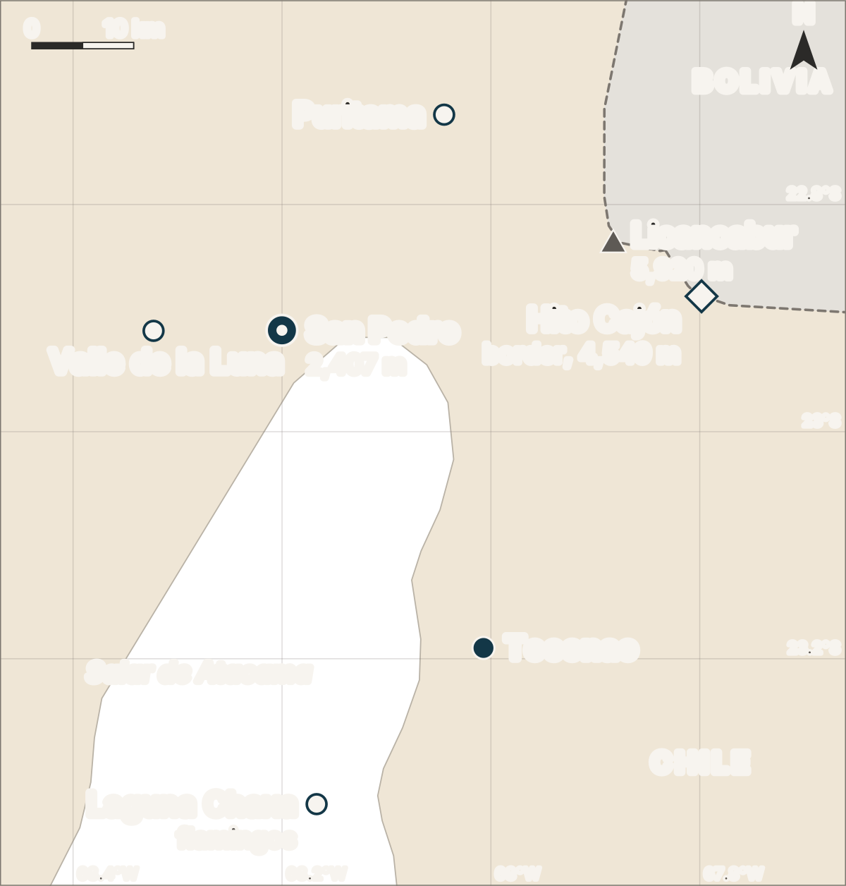
The 50 km around San Pedro. El Tatio is off the top of this map, 67 km to the north. Map by Latin Lands from Natural Earth data (public domain) and Wikidata coordinates.
Two things this scale makes obvious. The Valle de la Luna is next door, 13 km away, which is why it is usually an afternoon, not a day. And Bolivia is closer than the geysers: the Hito Cajón post is 41 km east in a straight line, El Tatio 67 km north.
That geometry is how we lay out the desert half of our 13-day Atacama and Patagonia route: four nights in San Pedro, the short trips first while your body adjusts, and El Tatio, the highest and earliest outing, on the last morning before the flight from Calama.
Getting there: Calama, then the road
The desert’s airport is El Loa, at Calama. From there San Pedro is about 100 km and an hour and a quarter by road, the transfer our Chile route uses. The drive is not a climb: San Pedro, at 2,407 m, is only 147 m higher than Calama.
Antofagasta, on the coast, gives the region its name, but it is 239 km from San Pedro in a straight line. For a desert trip it is the wrong door.
The borders: Bolivia at Hito Cajón, Argentina at Jama
San Pedro is a border town in all but name, and the map shows why so many routes cross here.
Hito Cajón, to Bolivia. According to Chile’s border authority, the complex is at 4,549 m on route CH-27, is open only to cars and minibuses, and its nearest town is San Pedro. The authority’s own opening notice put it 43 km from the town. It is the border on the road between San Pedro and the Uyuni salt flat in Bolivia: the fifteen-day version of our Uyuni salt flats tour ends by coming down it, from the Bolivian high plateau into San Pedro.
Paso de Jama, to Argentina. The complex, which sits on the Argentine side, is at 4,200 m and serves both San Pedro and Calama.
Altitude on the map: 2,400 m to 4,500 m in a morning
Every outing from San Pedro is a climb from the town, and the map’s altitudes are the reason the order of a visit matters.
| Place | Altitude | Rise from San Pedro |
|---|---|---|
| San Pedro de Atacama | 2,407 m | |
| Miscanti lagoon | 4,140 m | +1,733 m |
| Paso de Jama | 4,200 m | +1,793 m |
| El Tatio | 4,320 m | +1,913 m |
| Hito Cajón | 4,549 m | +2,142 m |
Sleeping in San Pedro and going up for the day is the sensible pattern, and the high outings belong at the end of a stay, not on the first morning. Our South America altitude guide explains the thresholds.
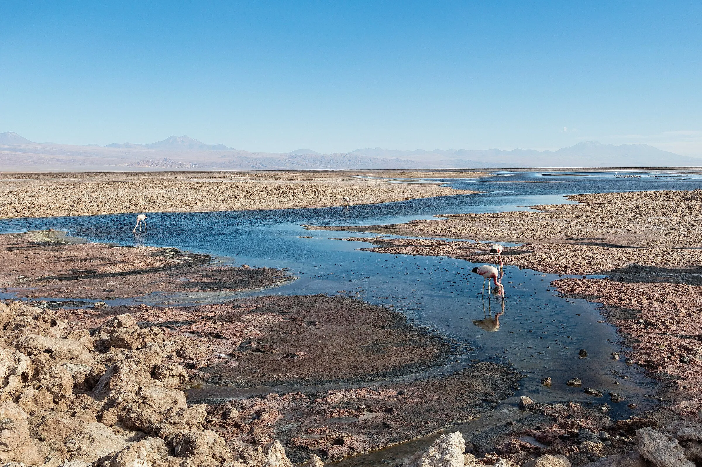
Laguna Chaxa, on the Salar de Atacama, in February. Photo by Diego Delso, CC BY-SA 4.0, via Wikimedia Commons.

The protected areas on the map
Several of the places on these maps are inside one reserve. CONAF, Chile’s forest service, manages the Los Flamencos National Reserve: 73,986.5 hectares in the commune of San Pedro de Atacama, created on 17 October 1990. Its sectors include the Valle de la Luna (sector 6), the Soncor system on the salt flat, where Laguna Chaxa is, and the Miscanti and Miñiques lagoons (sector 3).
Check CONAF’s page before you go: sectors close for weather. On 1 October 2026 it listed the Miscanti and Miñiques sector as closed by snow on route 23-CH, after a winter in which NASA recorded rare, widespread snow across the Atacama in August 2026, from the Andes to near the Pacific coast.
When the map changes with the season
The geography does not move, but access does. Our Chile route runs from October to April, and its own month table marks January and February as the worst months for the desert, when the summer storms of the high plateau bring floods and road closures; in January 2026 San Pedro itself flooded. In winter the risk is the opposite one: snow on the high roads, as above. The month-by-month detail, set against Patagonia’s season, is on the Atacama and Patagonia route page.
How these maps were made
We drew the three maps ourselves rather than embedding a commercial map, so that every point on them can be checked:
- Coastline, borders and the salt flat: Natural Earth, at 1:10 million, which is in the public domain. The salt flat outline is generalised at that scale.
- Places: the coordinates recorded for each one in Wikidata, San Pedro de Atacama being the first. Altitudes come from the same records, except the two border complexes, which come from Chile’s border authority.
- Projection: a simple equirectangular projection corrected for latitude, the same method as the route maps on our tour pages. It is accurate enough to compare distances at this scale; it is not for navigation.
- Distances: straight lines between coordinates. Where we quote a road distance, we say whose it is.
The coordinates used, in decimal degrees:
| Place | Latitude | Longitude |
|---|---|---|
| San Pedro de Atacama | −22.9108 | −68.2001 |
| Valle de la Luna | −22.9112 | −68.3230 |
| Puritama hot springs | −22.7208 | −68.0447 |
| Licancabur | −22.8336 | −67.8828 |
| Toconao | −23.1905 | −68.0071 |
| Hito Cajón (the pass) | −22.8808 | −67.7983 |
| Laguna Chaxa | −23.3281 | −68.1669 |
| El Tatio | −22.3314 | −68.0103 |
| El Loa airport | −22.4897 | −68.9036 |
| Calama | −22.4624 | −68.9272 |
| Miscanti lagoon | −23.7250 | −67.7650 |
| Paso de Jama | −23.2375 | −67.0764 |
| Antofagasta | −23.6464 | −70.3981 |
Asked before booking
The questions we get on this
- Where is the Atacama Desert?
- In northern Chile, between the Pacific coast and the Andes. The part most travellers visit is in the Antofagasta Region, around the oasis town of San Pedro de Atacama, at 2,407 m, which is about 239 km in a straight line from the port city of Antofagasta and 86 km from the El Loa airport at Calama.
- Is the Atacama Desert in Bolivia?
- No, it is in Chile. Bolivia begins at the Hito Cajón border post, at 4,549 m and 43 km by road from San Pedro de Atacama according to Chile's border authority. The post is open only to cars and minibuses, and the road beyond it climbs into the Bolivian high plateau towards Uyuni.
- Is the Atacama Desert in Argentina?
- No. Argentina is on the other side of the Andes, reached from San Pedro de Atacama by the Paso de Jama, about 121 km east in a straight line. Its border complex, which sits on the Argentine side, is at 4,200 m according to Chile's border authority.
- How do you get to San Pedro de Atacama from Calama airport?
- By road. The El Loa airport at Calama is about 86 km from San Pedro in a straight line, and the drive is about 100 km and an hour and a quarter. San Pedro is 147 m higher than Calama, so the transfer is not a climb; the climbs come later, to El Tatio at 4,320 m and the border at 4,549 m.
- How far is the Valle de la Luna from San Pedro de Atacama?
- About 13 km to the west in a straight line, the closest of the classic sights to the town. It is sector 6 of the Los Flamencos National Reserve, run by Chile's forest service CONAF, which warns that its trails sometimes close for sandstorms in winter or rain in summer.